Atlantic County, New Jersey
| Atlantic County, New Jersey | ||
|
||
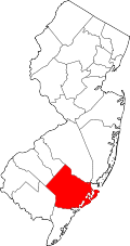 Location in the state of New Jersey |
||
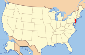 New Jersey's location in the U.S. |
||
| Founded | 1837 | |
|---|---|---|
| Seat | Mays Landing | |
| Largest city | Atlantic City | |
| Area - Total - Land - Water |
671 sq mi (1,738 km²) 561 sq mi (1,453 km²) 110 sq mi (285 km²), 16.44% |
|
| Population - (2000) - Density |
252,552 451/sq mi (174/km²) |
|
| Website | www.aclink.org | |

Atlantic County is a county located in the U.S. state of New Jersey. As of the 2000 Census, the population is 252,552. Its county seat is Mays Landing.[1]
This county is associated with (though not officially a part) the Delaware Valley area as well as the Atlantic City–Hammonton Metropolitan Statistical Area.
Contents |
History
All of what is known today as Atlantic County was once called Egg Harbor Township, the eastern half of the original County of Gloucester. Named as an official district as early as 1693, it was bounded on the north by the Little Egg Harbor River (now known as the Mullica River), and on the south by the Great Egg Harbor River and its southern branch the Tuckahoe River. Its eastern boundary was the Atlantic Ocean, but the western boundary in the South Jersey interior was not fixed until 1761.
Geography
According to the U.S. Census Bureau, the county has a total area of 671 square miles (1,737.9 km2), of which 561 square miles (1,453.0 km2) is land and 110 square miles (284.9 km2) (16.44%) is water.
Topographically, much of Atlantic County is low-lying and flat. The highest elevation, approximately 150 feet (50 m) above sea level, is found at two areas next to the NJ Transit passenger rail line just east of Hammonton. Sea level is the lowest point.
Adjacent counties
- Burlington County, New Jersey - north
- Camden County, New Jersey - northwest
- Cape May County, New Jersey - south
- Cumberland County, New Jersey - southwest
- Gloucester County, New Jersey - northwest
- Ocean County, New Jersey - northeast
 |
Camden County and Gloucester County | Burlington County | Ocean County | |
| Atlantic Ocean | ||||
| Cumberland County | Cape May County |
National protected areas
- Edwin B. Forsythe National Wildlife Refuge (part)
- Great Egg Harbor Scenic and Recreational River (part)
Demographics
| Historical populations | |||
|---|---|---|---|
| Census | Pop. | %± | |
| 1840 | 8,726 |
|
|
| 1850 | 8,961 | 2.7% | |
| 1860 | 11,786 | 31.5% | |
| 1870 | 14,093 | 19.6% | |
| 1880 | 18,704 | 32.7% | |
| 1890 | 28,836 | 54.2% | |
| 1900 | 46,402 | 60.9% | |
| 1910 | 71,894 | 54.9% | |
| 1920 | 83,914 | 16.7% | |
| 1930 | 124,823 | 48.8% | |
| 1940 | 124,066 | −0.6% | |
| 1950 | 132,399 | 6.7% | |
| 1960 | 160,880 | 21.5% | |
| 1970 | 175,043 | 8.8% | |
| 1980 | 194,119 | 10.9% | |
| 1990 | 224,327 | 15.6% | |
| 2000 | 252,552 | 12.6% | |
| Est. 2008 | 270,681 | [2] | 7.2% |
| historical census data source:[3][4] | |||
As of the census[5] of 2000, there were 252,552 people, 95,024 households, and 63,190 families residing in the county. The population density was 450 people per square mile (174/km²). There were 114,090 housing units at an average density of 203 per square mile (79/km²). The racial makeup of the county was 68.36% White, 17.63% Black or African American, 0.26% Native American, 5.06% Asian, 0.05% Pacific Islander, 6.06% from other races, and 2.58% from two or more races. 12.17% of the population were Hispanic or Latino of any race. 18.6% were of Italian, 13.0% Irish, 9.5% German and 5.2% English ancestry according to Census 2000.
There were 95,024 households out of which 31.70% had children under the age of 18 living with them, 46.50% were married couples living together, 14.80% had a female householder with no husband present, and 33.50% were non-families. 27.00% of all households were made up of individuals and 10.70% had someone living alone who was 65 years of age or older. The average household size was 2.59 and the average family size was 3.16.
In the county the population was spread out with 25.30% under the age of 18, 8.10% from 18 to 24, 30.60% from 25 to 44, 22.40% from 45 to 64, and 13.60% who were 65 years of age or older. The median age was 37 years. For every 100 females there were 93.60 males. For every 100 females age 18 and over, there were 90.20 males.
The median income for a household in the county was $43,933, and the median income for a family was $51,710. Males had a median income of $36,397 versus $28,059 for females. The per capita income for the county was $21,034. About 7.60% of families and 10.50% of the population were below the poverty line, including 12.80% of those under age 18 and 10.50% of those age 65 or over.
Government and politics
In 1974, Atlantic County voters changed the county governmental form under the Optional County Charter Law to the County executive form. The charter provides for a popularly-elected executive and for a nine-member Board of Chosen Freeholders, responsible for legislation. The freeholders are elected to staggered three-year terms in partisan elections. Five of the freeholders represent equally-populated districts[6]; four are elected from the county on an at-large basis.
Dennis Levinson is Atlantic County's Executive. The Current Board of Chosen Freeholders Members are:[7]
- Alisa Cooper, Freeholder At-Large (2011)
- Chairman James Curcio, Freeholder District 5, including Buena Borough, Buena Vista Township, Corbin City, Egg Harbor City, Estell Manor, Folsom, Hamilton Township (part), Hammonton, Mullica Township and Weymouth. (2012)
- Richard Dase, Freeholder District 4, including Absecon, Brigantine, Galloway Township and Port Republic. (2010)
- Frank Giordano, Freeholder At-Large (2012)
- Charles Garrett, Freeholder District 1, including Atlantic City (part), Egg Harbor Township (part) and Pleasantville. (2010)
- Joseph McDevitt, Freeholder At-Large (2010)
- Frank Formica, Freeholder District 2, including Atlantic City (part), Egg Harbor Township (part), Longport, Margate, Somers Point and Ventnor. (2012)
- Jim Schroeder, Freeholder At-Large (2011)
- Frank Sutton, Freeholder District 3, including Egg Harbor Township (part), Hamilton Township (part), Linwood and Northfield. (2011)
In state and national elections, Atlantic County is a reliably Democratic county, in contrast to the other three counties on the Jersey Shore, Monmouth, Ocean, and Cape May Counties, which tend to lean heavily Republican. In the 2004 U.S. Presidential election, John Kerry carried Atlantic by a 5.9% margin over incumbent George W. Bush, with Kerry winning by 6.7% statewide over Bush.[8] In 2008, the county voted for Barack Obama by a 15% margin over John McCain, with Obama winning New Jersey by 15.5% over McCain.[9] Atlantic County has backed the Democratic nominee in every Presidential election since 1992. However, in the 2009 Gubernatorial Election, Republican Chris Christie received 48% of the vote, defeating Democrat Jon Corzine, who received around 45%.
Municipalities
- Absecon (city)
- Atlantic City (city)
- Brigantine (city)
- Buena Vista Township (township)
- Collings Lakes
- Richland
- Buena (borough)
- Corbin City (city)
- Egg Harbor City (city)
- Egg Harbor Township (township)
- Estell Manor (city)
- Folsom (borough)
- Galloway Township (township)
- Pomona
- Hamilton Township (township)
- Mays Landing
- Hammonton (town)
- Linwood (city)
- Longport (borough)
- Margate City (city)
- Mullica Township (township)
- Elwood-Magnolia
- Northfield (city)
- Pleasantville (city)
- Port Republic (city)
- Somers Point (city)
- Ventnor City (city)
- Weymouth Township (township)
Education
Institutions of higher education in Atlantic County include:
- Atlantic Cape Community College in Mays Landing serves students from both Atlantic County and Cape May County.
- Richard Stockton College of New Jersey, in Pomona
- Rutgers, The State University of New Jersey at Atlantic Cape Community College, in Mays Landing - For more information on this program please visit http://www.rutgersataccc.org.
References
- ↑ "Find a County". National Association of Counties. http://www.naco.org/Template.cfm?Section=Find_a_County&Template=/cffiles/counties/usamap.cfm. Retrieved 2008-01-31.
- ↑ "QuickFacts: Atlantic County, New Jersey". U.S. Census Bureau. http://quickfacts.census.gov/qfd/states/34/34001.html. Retrieved 2007-03-01.
- ↑ "New Jersey Resident Population by County: 1880 - 1930". http://www.wnjpin.net/OneStopCareerCenter/LaborMarketInformation/lmi01/poptrd5.htm.
- ↑ "Geostat Center: Historical Census Browser". University of Virginia Library. http://fisher.lib.virginia.edu/collections/stats/histcensus/. Retrieved 2007-03-02.
- ↑ "American FactFinder". United States Census Bureau. http://factfinder.census.gov. Retrieved 2008-01-31.
- ↑ Atlantic County Freeholder District Map, accessed May 25, 2006
- ↑ Atlantic County Board of Chosen Freeholders, accessed March 1, 2007
- ↑ New Jersey Presidential Election Returns by County - 2004, NJVoterInfo.org. Accessed August 22, 2008.
- ↑ U.S. Election Atlas
External links
- Atlantic County website
- History of Atlantic County, New Jersey
- Rutgers at Atlantic Cape Community College
|
||||||||||||||||||||||||||
|
|||||||||||||||||